Cable Street
Damside Street crosses a very busy section of Lancaster's one-way system. This is the west end of Cable Street. Looking along Cable Street you can see some fine Georgian buildings on the left and the bus station on the right. Continue along Damside Street towards Sainsbury's.

Cable Street from the west end
Cable Street and Parliament Street were built as wide streets to link the New Bridge (i.e. the 1788 Skerton Bridge) with the centre of town. The original plan included the development of the land between these streets and the river. This did not take place then because of opposition by William Bradshaw and the economic decline at the end of the 18th century. Nos. 1 and 3 Cable Street were designed by Richard Gillow in 1759.
The Midland Railway Engine Shed 
The area around Cable Street circa 1890. Sainsbury's supermarket now occupies the site of the Public Baths, Engine Shed and turntable, though the facade of the baths has been preserved. The lines on the map running down the centre of Cable Street are the tramway.

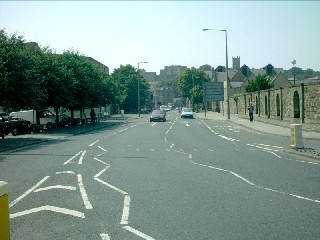
Cable Street from the east end
The area depicted in the map above (now Sainsbury's and its car park) is on the right-hand side of the photograph on the left. The Castle and Priory can be seen in the background.
Brockbank's Shipyard
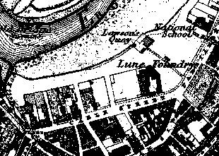
In the 18th century the site next to the river, where Sainsbury's now stands, was occupied by a boat-building yard. Brockbank's shipyard lay north of Cable Street, with Lawson's Quay adjacent upstream and the mill race downstream. Boat building had ceased by the time this map was made in 1845 but the Quay and the mill race can be seen, as can the Lune Foundry. Now retrace your steps. Walk back along Cable Street, cross by the traffic lights to the bus station side and turn left into Damside Street, the bus station on your left.
The Medieval Mill
The oldest recorded water mill in Lancaster was situated to the rear of today's bus station and Damside Street follows the line of the mill stream. It was known as Lune Mill and this was probably the mill referred to in the borough charter of 1193. It was Duchy of Lancaster property for most of its existence. It was demolished by the borough in 1769. As you walk along Damside Street, the bus station on your left, notice the steep drop at the back of the buildings on your right. This is thought to be a river cliff generated by erosion from the Lune which originally followed a more southerly route marked by the mill stream and, today, by Damside Street. The diversion of the river to its current more northerly course created an island which became known as Green Ayre.
Calkeld Lane

This lane on your right links Damside Street with Church Street. It is an ancient street with an Anglo-Scandinavian name meaning Cold Spring - there is in fact a spring in the basement of one of the adjoining buildings. The lane was probably built to give access to Lune Mill in the first half of the 13th century, or earlier.
At the end of Damside Street, enter North Road at St John's Church.


 Next
Next