Stonewell
Stonewell is situated at the junction of St Leonardgate, Church Street and Moor Lane. The entrance to Moor Lane is in the right foreground of this picture. The entrance to St Leonardgate is in front of the former church built in 1879 for the Congregationalists.

Speed's map of 1610 shows an offshoot of the mill stream (No. 9) ending in what appears to be a circular pond at this point. For centuries the mill stream was the town's main sewer.


The area around Stonewell in 1890. St Nicholas Street no longer exists, having been redevelped as the St Nicholas (St Nic's) shopping centre.
Turn left into Moor Lane.
Moor Lane
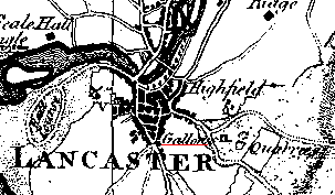
As its name suggests this was the road that led to the moor above Lancaster, an area now occupied by Williamson Park. The gallows were situated on the Moor as shown on Yates' map of 1786. The quarries which supplied much of the stone for buildings in Lancaster, possibly from as early as the Roman period, are also shown on this map. Note the Race Course to the west of the town.
The public drinking fountain at the entrance to Moor Lane was originally in Dalton Square. It was erected in memory of Thomas Johnson, solicitor and promoter of outdoor activities for young men. It was moved to its current location when the new Town Hall was built in 1909.

The Dukes Theatre

Originally St. Anne's Church, it was built in 1796 by a wing of the local Anglican church. It now houses the Dukes Theatre and quality Cinema.
From the entrance to the Dukes, walk ahead into cobbled Friar Street - so called because of the existence until the 1530s of a Dominican Friary on this site - and walk uphill to Dalton Square.


 Next
