White Cross
Walk up George Street to the bridge over Lancaster Canal. Take a look at the Canal and the White Cross mills before making your way down to the canal's tow path.
Lancaster Canal

Begun in 1792 with John Rennie as chief engineer, the Lancaster section of the canal opened in 1797. The building of the M6 motorway severed the canal to the north at Tewitfield. Southwards the canal now links with the Ribble at Preston. You can learn more about the canal and its history at the Lancaster Canal Trust's website.
White Cross Mills
The Storey family, oilcloth and table-baize manufacturers, had their mills at White Cross.
The White Cross mills from George Street canal bridge.


The first mill at White Cross, a steam-powered cotton mill, was built by Thomas Mason with the backing of Thomas Burrow in around 1802. Mason died in 1827 and the mill was taken over by George Burrow (the son of Thomas) and his partner Thomas Housman Higgin. Cotton manufacture declined in the 1840s and the mill passed through several hands before being bought by the Storey brothers and re-equipped for oilcloth manufacture in 1856. The map shows Springfield Barracks and the White Cross Mills in 1890. The original mill can now be seen in the middle of the complex. The White Cross site is now the home to many firms.
Springfield Barracks were built during the Crimean War as a training depot and stores for the Lancashire Militia. They were taken over by the Storeys to expand their White Cross complex. The Barracks moved to a new site in Bowerham, which became St Martin's College in the early 1960s, and is now part of the University of Cumbria.

South Road
Climb up from the tow path onto South Road at Penny Street Bridge.

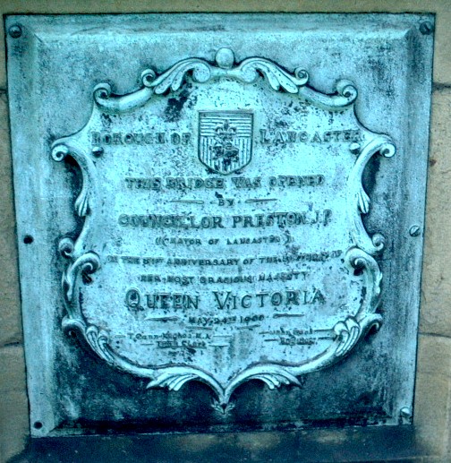
Penny Street Bridge was opened on 24th May 1900 as one of a series of improvements made at the start of the 20th century. The White Cross / Farmers' Arms / Toll House Inn on the left of the photograph and what was the Alexandra Hotel on the right were built around 1901 on the sites of previous inns. White Cross used to be a toll gate for goods entering Lancaster. It was also the site of an early local workhouse.
This plaque on Penny Street Bridge reads "Borough of Lancaster. This bridge was opened by Councillor Preston (Mayor of Lancaster) on the 81st anniversary of the birth of Her Most Gracious Majesty Queen Victoria. May 24th 1900". The original bronze plaque has been replaced.
Another plaque on Penny Street Bridge. This is the Borough coat of arms.

A cross stood at this site when Speed produced his map in 1610 (no. 21).


The Canal, looking west from Penny Street Bridge to the site of the Queen's Mill. Owned by Storeys it became the base for Rembrandt Intaglio, whose colour printing process was invented in Lancaster by Karel Klic. Armstrong-Siddeley occupied Queen's Mill during World War 2 to make aircraft components. It was a B&Q store and is now an Aldi supermarket.
Penny Street Bridge, looking east from the Canal.

Lancaster and Preston Junction Railway Terminus
Cross the road at the traffic lights and walk a short distance up South Road. A plaque on a building marks the site of the first railway station in Lancaster.

The first railway to reach Lancaster was the Lancaster and Preston Junction Railway which opened on 25th June 1840. The day was marked by a public holiday. The first train for Preston left with 200 guests and was hauled by two locomotives. Competition with the Canal caused problems which were resolved by the Canal Company leasing the railway. More problems came following the opening of the Lancaster and Carlisle railway in 1846. The two lines were joined but the Canal Company refused to surrender the L and P to the Lancaster and Carlisle. This situation eventually led to an accident at Bay Horse when an L and C express train ran into the back of an L and P slow train. The Lancaster and Carlisle railway took over the running of the line in 1849. The South Road station was then closed to passengers and used as a goods terminus until the late 1960s. Remnants of goods platforms can still be seen in the one of the Infirmary's car parks.
The terminus building looks more like a private villa than a railway station. It was designed by Edwin Gwyther of Birmingham. The front (shown in this photograph) contained the main entrance and offices and the back opened onto the platforms. It is now offices for Royal Lancaster Infirmary.

Walk back down South Road towards the Infirmary.
Royal Lancaster Infirmary
The Royal Lancaster Infirmary was built to the designs of Paley and Austin on land belonging to Springfield Hall (see map above). The oilcloth manufacturer and MP Norval Helme bequeathed the Hall to the hospital which was built between 1888 and 1896. Its building was funded by public subscription and it was opened on 24 March 1896 by the Duke and Duchess of York. It replaced inadequate premises on Thurnham Street which the dispensary had occupied since 1833.


A relief depicting the Good Samaritan. This relief used to stand over the entrance to the dispensary on Castle Hill and those before it.

Stained-glass window inside the entrance to the old part of the Infirmary. It depicts the healing of a sick woman by the touch of Jesus' cloak. Next to it are boards commemorating those who donated funds to the Infirmary before the NHS.
Cross South Road again at the traffic lights and head downhill for Penny Street.


 Next
